Natural Flood Management, the Witch, and the Basin.
After Scotland experienced some of the worst floods it has seen in decades (if not centuries), questions are being raised in many communities on the effectiveness and sustainability of hard engineered flood protection schemes. As a result, alternatives are being sought in the UK and around the world, and a measure appearing to be increasing in popularity is Natural Flood Management (NFM).
NFM is the alteration, restoration or use of landscape features in a way to reduce flood risk. Already, reports have emerged of the success of NFM in mitigating the recent flood events. An example of a few methods can include upstream water storage – field flooding, leaky dams – tree planting and woodland creation, and the re-meandering of artificially straightened river systems.
While some communities are developing projects to enhance the natural landscapes ability alleviate flooding, others are lucky enough to have these features in place already.
During the winter flooding, Montrose remained relatively dry; in comparison to Marykirk or Brechin. Similar to these two places, Montrose sits adjacent to a river – the South Esk. However, several natural features help separate us from the water.
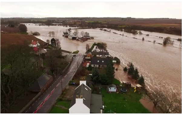
The river South Esk enters the Montrose basin from the west, and discharges to the North Sea, draining a catchment area of 564 km2 (SEPA). The river reached its highest ever peak flow record of 3.733m on 30/12/2015 (A record of 21 years), and over-topped its banks.
As seen below, before reaching the basin, the river floods adjacent land due to the low gradients of flat surrounding fields and meanders in the river system.
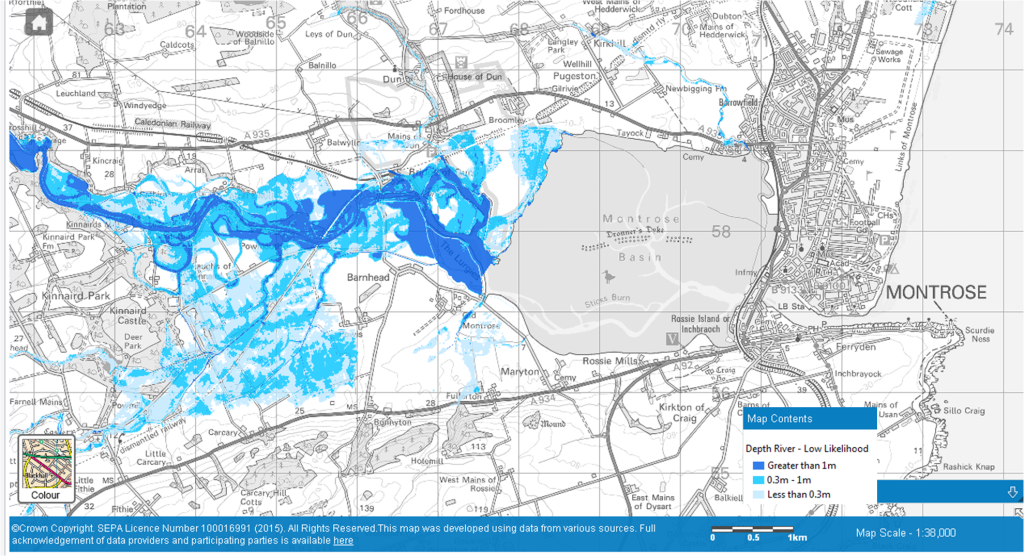
The meanders in the river system help slow the flow of water. In these areas of constriction, such as corners or the base of bridges, the water level rises, and eventually spills out onto the floodplain. The fields act as temporary storage for the surplus of water, reducing the amount of floodwater travelling downstream and into the Basin. This is one of two components of flood alleviation which Montrose benefits from.
The second is the Basin itself. Montrose Basin is a unique example of an enclosed estuarine wetland. Wetlands are among the world’s most important environmental assets, containing a vast number of plant and animal species compared with other areas of the world. In light of the recent flooding, their value has just gone up.
When the tide is out, floodwater from river channel or sea entering the Basin will spread out across the surface, dissipating energy and decreasing in velocity. The same applies for sea waves when the tide is higher; waves lose energy when travelling through tidal marshes or mudflats due to increased bottom friction (Smolders et al. 2015). However, attenuation is dependent on wetland properties, such as the size and elevation.
The Basin effectively acts as a natural buffer from an influx of floodwater and storm surges not only by dissipating wave energy, but also by providing flood water storage (Smolders et al. 2015). The name itself gives away its function; the large basin fills with water.
The point to be made is the importance of the Basin and its location, and the consequences that Montrose may face if it wasn’t there. Had Dronner’s Dyke of 1677 been a success, the current flood situation in Scotland may have been even closer to home. Luckily for us, nature (or the witch) was stronger, as the dyke perished in a storm (1678).
Reflecting upon the widespread damage left by the recent flooding, my appreciation has never been greater for the Basin, and more generally – wetlands.
Benedict Murray, Visitor Centre Assistant
Help spread awareness about the importance of wetlands, and celebrate Worlds Wetland Day this February 2nd 2016. Check out the site at http://www.worldwetlandsday.org/en/
“Wetlands are vital for human survival. They are among the world’s most productive environments; cradles of biological diversity that provide the water and productivity upon which countless species of plants and animals depend for survival”
#WorldWetlandsDay #WetlandsForOurFuture
References:
S., Smolders, Y., Plancke, S., Ides, P., Meire, S., Temmerman, 2015, Role of intertidal wetlands for tidal and storm tide attenuation along a confined estuary: a model study, Natural Hazards and Earth Sciences, Copernicus Publications, European Geosciences Union
Help protect Scotland’s wildlife
Our work to save Scotland’s wildlife is made possible thanks to the generosity of our members and supporters.
Join today from just £3 a month to help protect the species you love.
Preface
After Scotland experienced some of the worst floods it has seen in decades (if not centuries), questions are being raised in many communities on the effectiveness and sustainability of hard …